Events
Land Conference 2016 bBranding image
Land and Poverty Conference 2016: Scaling up Responsible Land Governance
March 14-18, 2016Washington, DC

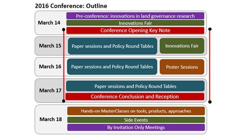
The 17th Annual World Bank Conference on Land and Poverty was held from March 14 to 18, 2016 at the World Bank Headquarters in Washington D.C. The conference theme was Scaling up Responsible Land Governance.

Now in its 17th year, the annual World Bank Conference on Land and Poverty brought together key stakeholders from governments, civil society, academia, the development community, and the private sector to discuss land policy design and implementation, impact evaluation and progress monitoring, and the latest research on these issues. This year’s conference paid special attention to working at scale, mainstreaming innovations, and sustaining investments in land governance. Conference participants discussed what can be done to guarantee inclusiveness, sustainability, and reliability, build capacity, and ensure that better land information and more tenure security contribute to wider societal objectives and progress towards the Sustainable Development Goals. 

Conference Structure

A pre-conference workshop on “Assessing Land Governance” was held immediately preceding the opening session on March 14. The keynote speaker for the 2016 Conference was Paul Romer, Professor of Economics, at the Stern School of Business at New York University, (see presentation).

Sessions comprising select papers and debates on important innovations and policy issues ran concurrently on March 15-17, together with poster presentations. The 2016 Innovations Fair featuring how innovations in technology and open data can help improve land governance at scale was held all day on Monday, March 14 and half day on Tuesday, March 15.  A post-conference learning day with MasterClasses was held on March 18 and offered hands-on classes to familiarize participants with cutting edge tools and techniques developed to help policy makers.  All session descriptions and papers have been published in the online agenda and recordings of selective sessions are available to watch online by clicking RECORDINGS.

Presentation by Klaus Deininger on the Closing Plenary, March 17 is available for download here.
Image


Session Room Number  Recordings

Monday, March 14, 2016

17:00–18:30  

Opening Keynote Plenary 

Opening Remarks by Asli Demirgüç-Kunt | Opening Remarks by Laura Tuck | Presentation by Paul Romer

Preston Auditorium Watch

Tuesday, March 15, 2016

8:30–10:00
Land Policy Development in Francophone West Africa Preston Auditorium Watch
10:30–12:00
Bridging the Digital Divide: Applying Lessons from the 2016 WDR for Land Preston Auditorium Watch
13:00–14:30
Spatial Development of African Cities MC 13-121 Watch
14:45–16:15
Roundtable Discussion on Land Governance Reform in the Arab World
MC 13-121 Watch
16:30–18:00
Planning for Urban Expansion Preston Auditorium Watch

Wednesday, March 16, 2016

8:30–10:00
Community Land Rights and Forests in Latin America: Lessons Learned
Preston Auditorium
Watch
Role of Land Policy in Agricultural Transformation and Inclusive Economic Growth: Implications for Africa MC2-800 Watch
10:30–12:00
Doing Business and Innovations in Quality of Land Administration
Preston Auditorium
Watch
16:30–18:00
Mainstreaming Land in Habitat III Preston Auditorium Watch

Thursday, March 17, 2016

8:30–10:00
Scope for Improving Land Governance through the Value Chain
MC 13-121
Watch
13:00–14:30
Shifting towards Sustainable Production systems for Beef and Oil Palm
MC 13-121 Watch
Preston Auditorium
Preston Auditorium

The 2016 Land and Poverty Conference would not have been possible without the support of our Sponsors and Partners below

Land Conference 2016 sponsors

The 2016 Innovations Fair was a full day and a half focusing on solutions for land administration and management. It was held on Monday, March 14 and half the day on Tuesday, March 15. Service providers and technology vendors were invited to present solutions in a show-and-tell day. The scope of the Innovations Fair covered land and geographic information systems, earth observation satellite imagery data acquisition and applications, aerial imagery, satellite positioning applications and location based services, online services and e-governance, land surveying, data conversion, data security, standards, systems interoperability, open systems, among other topics. The Innovations Fair encouraged hands-on interaction with conference participants looking for solutions to the land challenges of the post-2015 Development Agenda.


  • Image

    Airbus Defense and Space Inc.

    Through its Geo-Intelligence Portfolio, Airbus Defense and Space is recognized as a World leader in geo-information, pooling an unmatched access to Earth observation satellite imagery with unique expertise and decades of experience in one organization. We assist governments and the major donor agencies in Land Administration project definition, implementation and evaluation. To date, we have guided several countries in this component of their transition to a market economy and supported others in the implementation of various cadaster and land registration projects. Airbus covers the complete spectrum of services from data acquisition (both aerial and satellite) and data capture from existing records, through data processing, formatting and analysis to data management, hosting, serving and visualization. These processes often use systems and software that Airbus and their key partners have designed, developed and installed to support Land Tenure, Land Valuation, Land Use and Land Development applications.
  • Image

    CARIS USA

    Established in 1979, CARIS is a leading developer of geospatial software designed for the hydrographic and marine industries. Developed in cooperation with hydrographic clients and universities worldwide, CARIS software is designed to cater specifically for the marine GIS community, and is built on decades of hydrographic experience. The CARIS Ping-to-Chart solution includes products that address the need to manage bathymetric data sets containing billions of soundings, to support the development of multiple chart types from a single source, and to be able to distribute and interrogate high density bathymetry over the internet. CARIS offers training sessions, consulting and technical support services, as well as an extensive series of courses to make sure that its clients fully utilize the software’s capabilities. CARIS software innovates rapid production in the maritime environment and when appropriate link with land based products. Rapid turnaround of marine data to users and decision makers from unmanned platforms and real time processing are changing the way all marine and terrestrial geospatial data are handled.
  • cslt logo

    Compusult

    Compusult is a diversified software company with over 30 years of experience in geospatial data management software design and development. They are a leading global provider of interoperable, web-based, situational awareness software and geospatial management solutions across the enterprise and on mobile devices. Compusult’s Web Enterprise Suite (WES) software suite provides a secure, comprehensive, standards-based, Internet portal solution for the discovery and management of dispersed structured or unstructured geospatial data. WES components are based on SOA and support open, interoperability standards allowing seamless connections and sharing of information. Increased situational awareness can be formed increasing speed and accuracy of decision making. We've extended WES capabilities to mobile devices via GO Mobile and incorporated advanced event and incident management. Clients currently deploying WES include the National Geospatial-Intelligence Agency (NGA), DOD, DND, NASA, NRCan, and the USGS.
  • Image

    DigitalGlobe

    DigitalGlobe is a provider of imagery and information services to support customers in various markets including United States Government, International Civil and Defense, Energy, NGO's and others . DigitalGlobe is creating an accurate mosaic of the globe that can used to create land tenure in developing nations
  • FAO

    FAO creates and shares critical information about food, agriculture and natural resources in the form of global public goods. FAO plays a connector role, through identifying and working with different partners with established expertise, and facilitating a dialogue between those who have the knowledge and those who need it. By turning knowledge into action, FAO links the field to national, regional and global initiatives in a mutually reinforcing cycle. Appropriate and sustainable state-of-the-art technology is enabling the in-country application of the "Voluntary Guidelines on the Responsible Governance of Tenure of Land, Fisheries and Forests in the Context of National Food Security" (VGGT). Solutions for Open Land Administration (SOLA) supports cadastre and registration functions and services provided by a typical land office. Open Tenure supports a crowd sourcing approach to the collection of community and citizen based tenure relationship recording outside of formal land administration. The combination of SOLA and Open Tenure allows a flexible approach to the recording of legitimate tenure rights. These transparent, accessible and accountable computerized systems can create a basis for the responsible governance of tenure. The model implementations of SOLA and Open Tenure in various countries (e.g., Nigeria and Uganda) have proven their validity and are now ready for scaling up.
  • GAF AG Logo

    GAF AG

    GAF, headquartered in Munich, Germany, is an internationally active and renowned geo-consulting company. Founded in 1985, GAF began by providing services centered on Earth Observation. Today, GAF offers a broad range of geo-information services and applications, ranging from geo-data procurement (satellite data, DEM, land use and land cover data), image processing and analysis, information processing and software development, to the provision of turnkey technical assistance projects, customized spatial land management and monitoring systems. GAF has a long lasting experience in working with EO data, covering all aspects from data reception, distribution and procurement, digital image processing, image analysis and thematic image processing. In total, GAF has successfully completed more than 1000 projects in more than 100 countries since its formation. GAF is part of the Telespazio Group, which belongs to Finmeccanica and Thales, two European technology leaders.
  • Image

    Geomatys

    Geomatys is an independent French company specializing in GIS software with a philosophy to provide full transparency of their cutting edge products. Geomatys applies interoperability and robustness to all of their softwares in the mind to allow an efficient access to everybody. The Geomatys experts build customized geospatial solutions and provide their deep knowledge for a real time and money gain. As an innovative company, Geomatys is the editor of its own Open Source softwares like Geotoolkit, Apache SIS or Constellation-SDI. The Constellation-SDI product can handle a great variety of earth observation product and easily cross them with all kind of other specialized data. Thanks to their experts and satellite data, Geomatys can manage in many areas, including dryland, forests, floodwaters, and water and wastewater.
  • Geospatial_media and Communications Logo

    Geospatial Media and Communications

    Geospatial Media is a renowned media organisation striving to make a difference to world economy and society through geospatial knowledge. It achieves is objectives via publishing print and online publications, organising theme based national, regional and global conferences and trade shows and undertaking policy advocacy and commercial research. There is no other organisation offering end-to-end communications and business development strategies and avenues to the geospatial stakeholder community in order to enrich vertical sectors like land administration, agriculture, infrastructure, utilities etc. with geospatial content. The core of geospatial infrastructure lies in well established land administration. The relationship between geospatial sector and land is indisputable and as feeds into the other. Without geospatial technologies, cadastral mapping isn't possible and without integrated land information systems, geospatial content has little meaning for use by other sectors like governance, safety, disaster management, natural resource management etc.
  • IABG Logo

    IABG mbH

    IABG is a closely networked business group and offer integrated, future-oriented solutions in the sectors Automotive, InfoCom, Mobility, Energy & Environment, Aeronautics, Space, Defence & Security. The IABG Geodata service provides consulting and other services around the topics of Geodata and Geoinformatics. Their geospatial services and products combines a wide range of different location based information like EO data, high resolution environmental data, socioeconomic data, real time and crowd sourcing data to provide spatial analysis for different applications.Geospatial baseline information, planning as well as monitoring of measures has a high importance for the management of large scale land projects and their effect. EO can help to identify areas for specifically measures for DRR and land management.
  • Image

    K2 Geospatial

    Since 1995, K2 Geospatial has been committed to bringing spatial information and analysis tools within everyone’s reach by developing software solutions that provide effective visual aids to decision-makers. K2's map-based solutions connect systems, consolidate data and publish information traditionally managed and stored in silos. Employees and citizens can easily access this information, analyze it and have a real-time ability to decide. K2 Geospatial's solutions are powered by JMap, a map-oriented integration platform designed to connect silos and offer intuitive interfaces dedicated to non-technical users. K2 Geospatial’s solutions are designed for land, infrastructures, buildings management as well as for environmental, agriculture and public safety purposes. They are used by cities, regional governments, ports, airports, road authorities, railways, public utilities and natural resources companies daily. Powered by JMap, these solutions play a centralized role in the development of many smart city initiatives and projects.
  • Image

    LAND INFO Worldwide Mapping, LLC

    Founded in 1993, LAND INFO is a leading provider of high-resolution satellite imagery and value-added remote sensing solutions such as spectral classification/Object-Based Image Analysis for land-use/land-cover, agriculture & urban sprawl change detection mapping, 3d products such as DEMs (Digital Elevation Models), contours and building height data. LAND INFO Worldwide Mapping, LLC remote sensing solutions combine the global reach and currency of satellite imagery with advanced processing methods and software technologies to improve mapping results in challenging project locations. The company’s solutions are tailored to activities such as poverty mapping via extraction of buildings, roof-types, roads/types and agriculture from up-to-date satellite imagery. While not a replacement for census data and household-level surveys, information extracted from satellite imagery can serve as a timely and cost-effective complement to traditional economic indicators. New imagery solutions and remote sensing analysis technologies improve the mapping results of data sets needed to support projects such as responsible land governance. LAND INFO will show global examples including Africa, South Asia, Latin America and The Caribbean, and present a detailed case study illustrating poverty mapping of Sri Lanka.
  • Image

    Luciad

    Luciad is passionate about geospatial software with a reputation for cutting-edge excellence worldwide. Their real-time situational awareness geospatial software components are known for their flexibility, high performance and accuracy. To understand the complex triggers of poverty such as disasters or historical reasons, solutions have to manage both archived and real time data published by multiple sources. Luciad components help build decision making applications managing various and large datasets in an efficient and performant user interface. They're products are based on International Standards (ISO, OGC, W3C, …) to help exchange quickly and easily the information between stakeholders. Luciad products are innovative due to the advanced visualization and analysis algorithms and the unique capability to deal with large amounts of historical and real-time big geospatial data sets.
  • pixia logo

    PIXIA Corp

    PIXIA Corporation creates high-performance scalable data access solutions for large geospatial data sets, Wide Area Motion Imagery (WAMI), and Full Motion Video (FMV). Its core technology focuses on increased storage I/O, data scalability and interoperability across large datasets. PIXIA's HiPER LOOK and KiOSK product lines deliver an innovative capability to manage enterprise level geospatial data holdings and to create self contained geospatial web servers, compressed to a thumb drive or USB drive, and delivered to network disconnected or bandwidth disadvantaged users. These HiPER DRIVES are interoperable with any OGC compliant analytical tool. PIXIA's technology will enable archive, management, visualization, dissemination, analysis, and consumption of geospatial big data leveraged for land management, human terrain mapping, natural resource management, land use studies, agriculture, city planning, urban development, environmental science, and general planning, policy, and oversight.
  • PYXIS logo

    PYXIS

    The PYXIS innovation™ was founded in 2003 and is located in Calgary, Alberta, Canada. PYXIS leads the world in the use of discrete global grid system (DGGS) technologies, a powerful Digital Earth reference now becoming an OGC Standard. The PYXIS Studio is a web based software built on the DGGS allowing users to search for all geospatial content in the world – inside and outside our network. The Studio simplifies the complexity of accessing geospatial content down to a google like search. External content used in a Studio is added to and becomes accessible – by permission – to others nodes in the network. PYXIS is committed to open standards and free access and use of our network and development platform. With the PYXIS Studio users can make their insightful discoveries sharable with a simple URL or to a web embeddable Globes – next generation web maps but smarter – with a press of a button. These Web Globes are powerful and easily customized. Teachers are presently using their Studio to create Web Globes for their students as young as 8 in several GeoLiteracy sites we have in Canada and Australia. But here is the real disruption – Web Globes are Studios, too. A student can add their own content, styles, and reshare their Globe. Maps are no longer static one off productions – they will have a life and can be passed on and on forever. Globes are the nodes on the network. There is a strong willingness to adopt the PYXIS solution to enable the next generation geospatial platform - Digital Earth - where geospatial knowledge is accessed on-demand.
  • Image

    ProSoft Alliance, Ltd

    ProSoft Alliance brings together extensive experience in the business analysis, design, development and implementation of innovative Land Management Systems with real-world, practical capacity-building expertise to ensure business sustainability and efficiency. Their team of land administration experts have developed an innovative cadastre-registration software system, InnoLA, to meet the needs of Title/Deeds Registration and other Land Administration sectors. InnoLA is a spatially-enabled, web-based solution which promotes open source technologies, the standardization and transparency of business processes and transactions, and enterprise data-sharing needs while ensuring the priority of secure tenure. It is a paired mobile/desktop solution that allows governments, customary groups, and individual citizens to record customary or statutory land rights. Because InnoLA is private- or hybrid-cloud-based, it's a quickly deployable, easy to use, and lightweight fit-for-purpose solution to gathering geotagged data on the ground.
  • Image

    senseFly

    senseFly designs, manufactures and sales small UAV systems for civil purposes such as mapping, land surveying, precision agriculture and inspection. senseFly's technology allows to survey fields acquiring up to date data which is crucial and offers a great advantage compared to traditional survey methods in terms of efficiency and time saving and in terms of costs if compared to the use of satellite imagery. senseFly's drones are used for mapping, land surveying and land management, and have been working with the World bank in the past for several missions of urban planning and development in Tanzania as well as flood damage assessment and building resilient infrastructure.
  • Image

    Thomson Reuters

    Thomson Reuters is the world’s leading source of intelligent information for businesses and professionals. We combine industry expertise with innovative technology to deliver critical information to leading decision makers in the financial and risk, legal, tax and accounting, intellectual property and science and media markets. Thomson Reuters' product seeks to directly provide easy-to-use, cost-effective, quickly deployable, and leading-edge technology to even the most remote areas of the world to empower governments, customary groups, and citizens to begin recording rights. The product is a paired mobile/desktop solution that allows governments, customary groups, and individual citizens to record customary or statutory land rights. Because it is private- or hybrid-cloud-based, it's a quickly deployable, easy to use, and lightweight fit-for-purpose solution to gathering geotagged data on the ground.
  • Image

    US Agency for International Development

    The U.S. Agency for International Development (USAID) works to improve land and resource governance and strengthen property rights for all members of society, especially women. USAID will demonstrate an innovative suite of Mobile Applications to Secure Tenure (MAST), which include a mobile phone-based app for documenting and recording formal land rights that is currently being piloted in Tanzania, a tablet-based application for documenting and recording customary land rights currently being piloted in Zambia, and two mobile applications for improving conservation and resilience through better land-use planning and land management currently being piloted in Kenya and Namibia. At the Innovation Fair, USAID staff will show how recent innovations in open source mobile technologies can be used to effectively document and strengthen land and resource rights. USAID’s tools and approaches also place a strong emphasis on gender, from ensuring that women participate in demarcation and community mapping exercises to mobile apps that prompt users to capture photos of both husbands and wives when documenting land rights.
  • what3words logo

    what3words

    what3words has developed a global location reference and address system based on words. It is a simple and precise way to communicate location around the world. Being able to define specific points on a property or an area or land or the property itself can be problematic where there is no address system. what3words has already been used to provide addressing the favelas in Rio, Brazil, for medicine delivery in the townships of South Africa and in many other global regions. The what3words app is free for ALL citizens around the world and they can search and discover their own 3 words address. For larger government installations or enterprise applications, what3words has been integrated with industry leading software systems, such as ArcGIS and Safe Software.

Live Agenda
  • Land and Poverty 2016: Click button below to view the draft agenda of the conference


Photos

Land Conference 2016

Conference photos taken by Deepa Shivaram and Nataliya Makarenko during conference days.


Welcome