Building a resilient future: experts from the City Climate Finance Gap Fund (The Gap Fund) share how they worked with policy makers in Panama to enhance last-mile connectivity, spur urban regeneration, and support disaster risk reduction in vulnerable communities.
The district of San Miguelito is located in the heart of the Metropolitan Area of Panama, in a hillside setting that is highly prone to landslides. With an estimated population of over 350,000 residents, San Miguelito is the second most populated district in Panama, and the most densely settled. Since the 1960s, the district has seen the most large-scale informal development in Panama City, with 50% of housing being informal, and 20% being social housing (compared to 30% and 10%, respectively, for the district of Panama). More than half of the district’s population is low-income, with crime being an issue in certain neighborhoods. Around half of residents live in hillside communities, making them vulnerable to landslides, floods, and other hazards. Disorganized plots, a poorly integrated and insufficient road network, and few -quality public spaces and community facilities have characterized the district’s informal expansion.
This unregulated, unplanned growth has significantly limited public transport in and out of the district. Steep roads and narrow streets make it difficult for public buses to pass and to provide much needed transport services. Practicable bus routes are few, longer and more time consuming for users. As a result, people use private vehicles, taxis, and smaller informal buses that can navigate the narrow streets, leading to increased congestion and pollution. San Miguelito is the second largest contributor to greenhouse gas (GHG) emissions in the metropolitan area after the district of Panama. It generates an estimated 2.86 tCO2 per capita, with nearly half of these originating from transportation (IDB Climate Change Mitigation Study for Panama City’s Metropolitan Area, 2016).
Designing and costing a public cable car system
To address these chronic urban connectivity and accessibility challenges, the government is planning to build a public aerial cable car system as part of the new master plan for Panama City’s Metro System. Building a cable car system in a low-income urban area like San Miguelito presents a major opportunity to assess and conceptualize potential urban improvements around the transport corridor influence area, and will support the full integration of social, economic, and environmental benefits for its residents.
The government has already developed a preliminary system design for the cable car network. The design outlines a primary north-south corridor spanning 9 kilometers that connects the major demand centers. There is also potential to expand the north-south line with a 3-kilometer east-to-west branch. The final layout will depend on the results of the technical feasibility phase.
The World Bank's technical assistance and suggestions to humanize San Miguelito are fundamental for the comprehensive and equitable development of the city of Panama.
Jose Agustin Espino
Director of Territorial Development, Ministry of Economy and Finance (MEF), Panama
Proposed cable car line and stations for San Miguelito, Panama
Integrating urban regeneration, connectivity, and disaster risk reduction
Enter the Gap Fund, which financed a group of specialists that teamed up with the Municipality of San Miguelito and central government and community leaders in 2021 to re-imagine and integrate San Miguelito's urban infrastructure with the cable car blueprint.
The Gap Fund supports cities in developing countries with early-stage technical assistance for low-carbon and climate-resilient urbanization analytics, plans, and projects. From mid-2021 through 2022, it supported the mapping, designing, and costing of urban interventions around two future MetroCable stations in Samaria and Torrijos Carter – areas prioritized based on their density, need, and economic potential. The sites for the two cable car stations were identified, along with project designs for last-mile connectivity, urban regeneration, and disaster risk reduction, with an indicative budget estimated at around US$67 million.
Last-mile connectivity: improving street and pedestrian systems
The Gap Fund recommended focusing on last-mile connectivity, including improving streets and walkways to give residents easy access to future MetroCable stations. They envisioned streets as vital public spaces and stressed pedestrian and cyclist safety and comfort, while seeking ways to reduce urban heat. They aimed to:
Promote active mobility and introduce pedestrian-friendly streets with measures including continuous sidewalks, urban lighting, furniture zones, raised crosswalks and improved stairways and pathways with universal accessibility standards;
Seek design standards that increase women’s and children’s safety;
Enhance climate resilience by planting trees and shrubs in “rain gardens” to absorb urban heat and rainwater, and place electric cables underground;
Increase safety with segregated bike lanes and designated vehicle-parking areas.
Current vs proposed situation at Samaria Hill stairways and paths, with adjacent rain gardens and underground water channels to improve water management and mitigate landslide risks – Images by Urbam EAFIT
Key to urban transformation: mixed-use public spaces to support culture, sports, recreation, and entrepreneurship
These recommendations revolve around leveraging streets and public zones to spur mixed-use activities and economic growth. Local community initiatives are embedded in the recommendations, which support the growth of culture, sports, recreation, and entrepreneurship. The recommendations include:
Creating linear parks along rivers and streams;
Repurposing bridges into leisure and social zones;
Promoting green spaces, walkways and sports areas, and;
Adopting energy efficient systems in public facilities.
The recommendations also envision the creation of outdoor learning spaces - or “river labs” - on terraces between schools and rivers. These could encourage students to use nature for educational purposesand open up schools for alternative community uses.
Disaster risk reduction: enhancing water and risk management strategies through nature-based solutions
The recommendations to reduce disaster risk focus mainly on using Sustainable Urban Drainage Systems and Nature-based solutions. These strategies aim to enhance water and risk management by controlling variables like water velocity and infiltration. The measures put forward include:
creating areas for surface water retention and green swales;
installing rainwater storage tanks to supply water to public facilities.
In Samaria, an area with steeper slopes, the plan also recommends the integration of water channels, culverts, rain gardens, and relocation strategies for flood-prone zones.
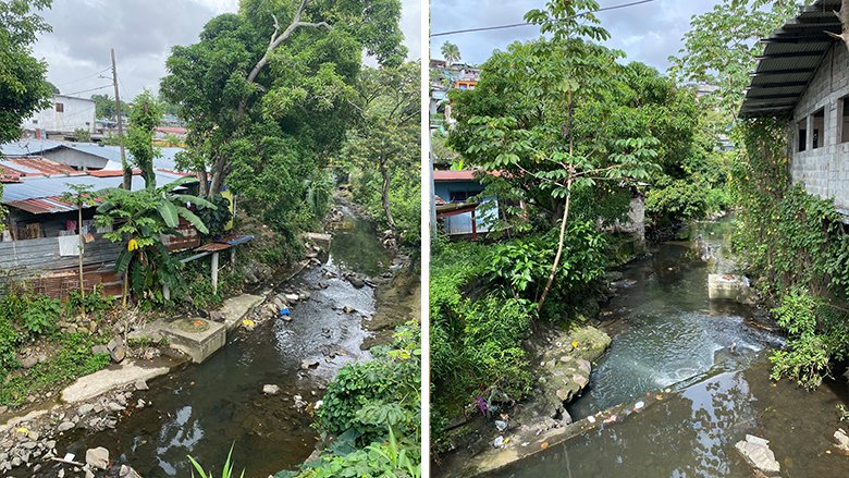
Houses at risk at the Matias Hernandez River in Samaria – Images by Urbam EAFIT
Bringing together key stakeholders across local and national government
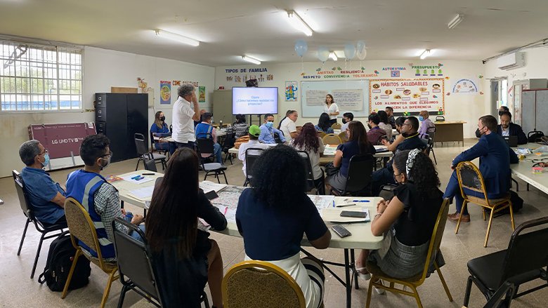
In July 2022, the Gap Fund team carried out a workshop with the Municipality of San Miguelito and sector ministries of Panama to review the proposals. The event was an opportunity for decision-makers to share feedback, prioritize projects, and explore how to better collaborate to implement the proposed interventions.
Stakeholders from the Vice-Ministry of Territorial Planning, the Public Infrastructure Coordinating Unit (UCIP), the Climate Change Directorate of the Ministry of Environment, the Ministries of Education and Culture, the Municipality of San Miguelito, Panama Metro’s Planning Directorate, the MiBus bus company, Belisario Porras Communal Board, San Miguelito Professional and Technical Institute, the National Police, and the Ministry of Health’s Bay Sanitation Program shortlisted potential projects for development.
This dialogue emphasized aspects like enhancing public transport, recognizing public zones as urban regeneration catalysts, integrating non-infrastructure-focused social projects, and prioritizing public over private infrastructure. Stakeholders also prioritized projects aligning with regulatory and urban planning instruments and offering high synergy potential.
Jose Agustin Espino, Director of Territorial Development, Ministry of Economy and Finance (MEF), said: “The World Bank's technical assistance and suggestions to humanize San Miguelito are fundamental for the comprehensive and equitable development of the city of Panama. As the country embarks on a sustainable and resilient development path, having long-term project proposals that integrate risk management into territorial management becomes essential.”
Jose Batista Gonzalez, Vice-minister of Territorial Planning, Ministry of Housing and Territorial Planning (MIVIOT), said the partnership with the Gap Fund had supported government officials in building capacity. The work carried out by the Bank in San Miguelito is key, as it gives the government tools to inform the sustainable, resilient, and transport-oriented development of this sector towards the future."
Stakeholders at the workshop held in July 2022 at a local school (San Miguelito Professional and Technical Institute) – Images by Urbam EAFIT
Impact: embedding the recommendations into strategic planning
Policy makers in the national government have pledged to include the Gap Fund recommendations in their strategic planning efforts. The Vice-Ministry of Territorial Planning looks forward to including these projects in the forthcoming San Miguelito District Plan, updating provisions such as zoning regulations and road easements, while also putting forward an investment action plan.
Panama Metro’s Planning Directorate has also already incorporated a conceptual plan, developed in the prior phase, as a key reference in bidding documents for the feasibility studies of the MetroCable system.
Ana Laura Morais, Director of Planning of the Metro de Panamá, underscored the project's importance for San Miguelito's urban revitalization, urging subsequent administrations to factor in these efforts during investment planning.
She said: “It is important for the next Government administrations, both at the national and local levels, to embrace this work to the extent that the prioritization of investments in the sector is made possible.”
Looking ahead
Government representatives confirmed that some of the Gap Fund recommendations will directly inform relevant urban planning, transport, and disaster risk reduction priorities. This includes prioritization of investments to reduce contingent liabilities related to natural hazards in vulnerable areas in the country. The next steps for implementing the Gap Fund’s interventions involve conducting detailed studies and designs for executing the recommendations.
Inés María Samudio de Gracia, Director of Public Infrastructure of the Ministry of Public Works, said: “The work carried out by the World Bank has been beneficial for the vulnerable communities of San Miguelito. The proposals would transform the district’s quality of life. We hope that this motion can be replicated in other districts in the Province of Panama.”
Felipe Montoya, Urban Specialist at the World Bank, said: “The effort that we were able to carry out in San Miguelito through the support of the Gap Fund allowed us to bring together important stakeholders – both at the national and local level – to discuss and agree on the district’s priorities for a more resilient future.”
Blogs
WHAT'S NEW
This site uses cookies to optimize functionality and give you the best possible experience. If you continue to navigate this website beyond this page, cookies will be placed on your browser. To learn more about cookies, click here.