(July 2023) --In the hours and days following a devastating flood in June 2021, when a deluge of sediment and debris swallowed parts of the Melamchi River Valley in central Nepal, authorities scrambled to recover the dead and injured while evaluating the mountain risk in upstream reaches.
With mountain roads blocked by rocky debris and skies too cloudy for helicopters, it was unclear how to assess the damage and the potential risk of more landslides among some of the world’s highest peaks.
That’s when authorities decided to send in the drones.
As climate impacts increase across South Asia, drone technology is increasingly being used by governments there to respond to climate-induced disasters and to map out future geohazard risks. Otherwise known as unmanned aerial vehicles, drones can produce orthophotos and topographical maps that can be more granular and detailed than satellite imagery, providing valuable real-time information to inform rapid response. Specialized drone sensors can detect minute topography changes that could help provide early warning and reduce the impact of future landslides or floods.
Climate change is reshaping the Himalayan slopes. Record-breaking glacial melt has accelerated across the mountains, posing disastrous consequences for hundreds of millions of people in the South Asian plains. In the summer of 2022, unusually severe monsoon rains combined with Himalayan glacial melt produced a super-flood that submerged one-third of Pakistan and displaced over thirty million people.
Nepal, located in the central part of the Himalayan range, is at the epicenter of these rapid changes. The government of Nepal will need to become more resilient to an unpredictable and changing climate through the increased use of disruptive technologies, including drones, satellite technology and geospatial analytics. Ever since the country’s 2015 earthquake, when international agencies brought in drone technology to help in the recovery efforts, a local drone ecosystem has taken root. Now, Nepal’s piloting of drone technology could serve as a model to nearby countries that are struggling with climate’s devastating impacts, evidenced by drone services provided by Nepal’s private sector consultant to Bhutan for Multi-hazard Risk Assessment.
“It is astonishing how rapidly drones have become mainstream in disaster response and climate risk mitigation, with an exponential drop in costs,” said Abhas K. Jha, the World Bank’s South Asia region practice manager for Climate Change and Disaster Risk Management. “Our efforts in Nepal and South Asia are to enhance local capacity to benefit from such cutting-edge technology through enabling regulations and legal frameworks. In time, we hope to assist in the creation of a vibrant ecosystem of players, private and public, who will be comfortable using drones for a variety of purposes like creating flood and landslide risks maps and emergency response logistics.”
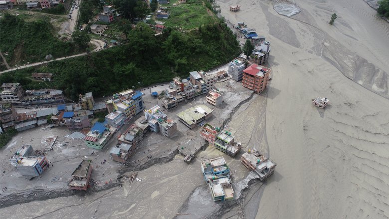
A glacial torrent
On the night of June 15, 2021, after consecutive days of rain, the Melamchi Bazaar was hit by a heavy flash flood from two tributaries – the Melamchi and Indrawati rivers – resulting in 5 deaths and 20 missing persons. The deluge wiped out everything in its path – houses, trees, power lines, rice paddies - and submerged a water supply headworks, critical to keeping the capital, Kathmandu, supplied with drinking water, under 16 meters of sediment. Downstream, in the Melamchi Bazar, a thick deposit of sediment and debris gave the appearance of a lunar landscape.
In the chaotic aftermath, Nepal’s National Disaster Risk Reduction and Management Authority (NDRRMA) authorized a drone survey with two objectives; one to identify damaged houses and map out inundation areas, and the second to record the topographical changes caused by the massive erosion and deposition. An additional survey using satellite-based Synthetic Aperture Radar (SAR) analysis was conducted to identify which areas were vulnerable to more landslides.
“Working alongside the World Bank, the quick and focused data collection and analysis in an area that was primarily inaccessible and unstable allowed us to identify the houses that were damaged, prioritize resource allocation and understand residual flood and landslide risks,” said Anil Pokhrel, Chief Executive of the NDRRMA. “The other alternatives, such as flying helicopter, would have been very expensive, and satellite imagery was beyond our capacity.”
Nepal’s drone ecosystem is taking flight
In the past, when disasters struck, international search and rescue drone experts would often be the first on the scene, especially in 2015 when a 7.8 magnitude earthquake flattened parts of Kathmandu, killing thousands. Since then, thanks to advancements in local technology and youth curiosity, a vibrant drone ecosystem has begun to take flight across the country.
“After the earthquake, organizations in Nepal began to realize the value of drone technology,” said Uttam Pudasaini, executive director of Nepal Flying Labs, an organization that promotes the use of drones for social good. “The Melamchi disaster was an opportunity to deploy local drone experts and capacity because an ecosystem had evolved since the earthquake. If you have local people empowered to use drones, then you can quickly deploy them when a disaster strikes.”
Despite Nepal’s increasing use of drones as a cost-effective technology to respond to climate and disaster risks, there are still some obstacles to their widespread application. In Melamchi, following the flood, the drone deployment was initially delayed due to permit and logistical constraints to reach high lands with very limited access. In addition, strict import rules have created challenges for transferring more drone technology and spare parts into the country. The data collected from drone flights is seldom available for reuse, posing a challenge for academia and other experts to undertake further analytics and research. However, the government of Nepal is keen to improve drone policies and regulations to meet the growing use of drones across the country, in addition to eliminating barriers to entry and ensuring their safe and secure operation.
These challenges provide an opportunity to boost the local drone ecosystem in Nepal and build sustainable capacity for drone pilots, analysts, engineers and entrepreneurs, a model that has shown promising results in Africa through the African Drone and Data Academy, supported by UNICEF. As a result, the World Bank, with grant funding provided by the Korean World Bank Partnership Facility (KWPF), is engaging with the government, the private sector, academia, and local drone experts to better understand how it can support Nepal’s burgeoning drone ecosystem and build sustainable capacity through partnerships for Green Resilient and Inclusive Development across several sectors, including climate and disaster response.
Drawing from ongoing work and initiatives across South Asia, the World Bank’s engagement with the government of Nepal seeks to understand opportunities to support policies that can provide an enabling environment to support resilience through drone innovation, capacity building and regulation to scale drone adoption in the public and private sector. For example, in Bhutan, the World Bank is helping to support the use of drones and other geospatial support systems to generate nationwide multi-hazard risk information, supported by a private sector consultant from Nepal.
For local drone experts like Uttam Pudasaini, the way ahead is clear: “As we are operating only with procedural guidelines, one major priority would be to support the government to amend regulatory measures, including licensing provisions for drones,” he said. Pudasaini believes that drone technology alone is not sufficient to stem climate impacts and that combining the use of drones to collect geodata with other technologies such as satellite imagery is critical.
But as climate impacts increase across South Asia, and with advances in technology, using drones for climate and disaster risk mapping will likely help Nepal deliver enhanced resilience and reach new heights in the battle against climate change.