Skip to Main Navigation
FEATURE STORYNovember 21, 2022

Opening up opportunities for participatory wildlife monitoring in the Amazon with camera traps

Amazon Sustainable Landscapes Program

Source: Fototrampeo SFPM Orito Ingi-Ande, Putumayo

HIGHLIGHTS

  • Camera traps and technology accessible to communities and governments can be powerful tools for conservation decision making.
  • The GEF-funded, World Bank-led Amazon Sustainable Landscapes regional project partnered with Wildlife Insights (WI) to develop a dedicated data explorer tool that assesses and analyzes images of wildlife captured by camera traps.
  • In four pilot sites in Brazil, Colombia, and Peru, the tool and capacity built around it helped identify the sites’ richness in species and provide key information to design wildlife ecological corridors and motivate ongoing and future conservation activities.

One of the best, easiest, and most effective ways to observe wildlife in their natural habitat is not always through the naked eye—but through images and video captured by camera traps. These small and powerful tools have become widely popular, including in the Amazon, and provide an excellent means to improve the surveillance and monitoring of wildlife populations.

Camera traps are easy to set up and can capture, via a photograph or video, a wide diversity of key terrestrial species triggered by a sensor when an animal moves past. If designed and deployed correctly, camera traps are a cost-effective way to quickly collect many images—one single camera can often collect hundreds or thousands of images in the span of a few weeks. Despite the volume of camera trap data collected in regions like the Amazon, most of it remains “invisible” because these data are voluminous, difficult to organize, analyze, synthesize, and share with others. Generally, local communities and non-experts lack the capacity and know-how to access and use the analytical tools to process the collected data. Nonetheless, if correctly used, the potential for camera traps is huge, as the resulting data can be used to measure ecosystem health and monitor if conservation activities are delivering the expected results in terms of species diversity and abundance.

Camera traps can also play an important role in efforts to control illegal wildlife trade and monitor species that are at high risk to transmit disease and not easily monitored by casual observation. In the context of COVID-19 travel restrictions, the need to promote community monitoring mechanisms with the use of technology was also brought to the forefront, which not only reduces the necessity for external technicians to travel and lowers the carbon footprint, but importantly builds local capacity.

Responding to the challenges to use and process the information coming from camera traps, the Amazon Sustainable Landscape (ASL) program’s regional project identified the need to design and pilot an analytical tool to gather, organize, visualize, and analyze information captured by camera traps within its area of intervention and enable conservation management-related decision making. The ASL, financed by the Global Environment Facility (GEF) and led by the World Bank, aims to improve integrated landscape management and ecosystem conservation in priority areas of the Amazon in Bolivia, Brazil, Colombia, Ecuador, Guyana, Peru, and Suriname.

To help stakeholders make the most of these data, build capacity, and exchange knowledge, the ASL brought Conservation International (CI) on board as one of the organizations leading Wildlife Insights (WI)—a cloud and artificial intelligence-enabled platform built by CI, Wildlife Conservation Society (WCS), WWF, and other partners to facilitate the processing, management, and analysis of camera trap data. The resulting key product, the ASL Data Explorer tool, was developed within the WI platform for the ASL to gather and facilitate the processing, management, and analysis of data from the cameras collected by its national projects. The tool provides users an easy way to explore the data collected through camera traps, obtain essential information on biodiversity, and run estimates of several analytics, including comparing the presence of species within and outside of a protected area.

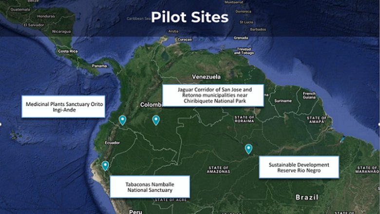
The activity funded by ASL helped to strengthen capacity of project stakeholders (local communities, environmental authorities, technicians, and park rangers) to collect and use camera trap data, in conjunction with other relevant data, and to evaluate biodiversity outcomes achieved through their interventions. The activity included virtual and in-person training workshops supported by WCS and WWF in four pilot sites in Brazil, Colombia, and Peru. Materials to facilitate training were prepared including a comprehensive step-by-step guide to learn how to use the WI platform in English, Spanish, and Portuguese, practice assignments (in Spanish), as well as specific guides for some of the sites like Tabaconas and Orito Ingi-Ande Sanctuary.
Amazon Sustainable Landscapes Program

Map showing the locations of the four pilot sites

Stakeholders from the pilot sites saw the tool as an efficient way to obtain valuable information about biodiversity in each site by answering specific biodiversity-related questions (e.g., presence and abundance of species), informing management plans, and encouraging conservation activities (e.g., corridors planning). They also validated the effectiveness of conservation measures implemented in the protected and conserved areas of intervention. Many sites reported that the results from this activity motivated stakeholders to explore other conservation activities. At the final stage of the activity, the ASL hosted a webinar to share the results to broader audiences and showcase this important collaborative effort.

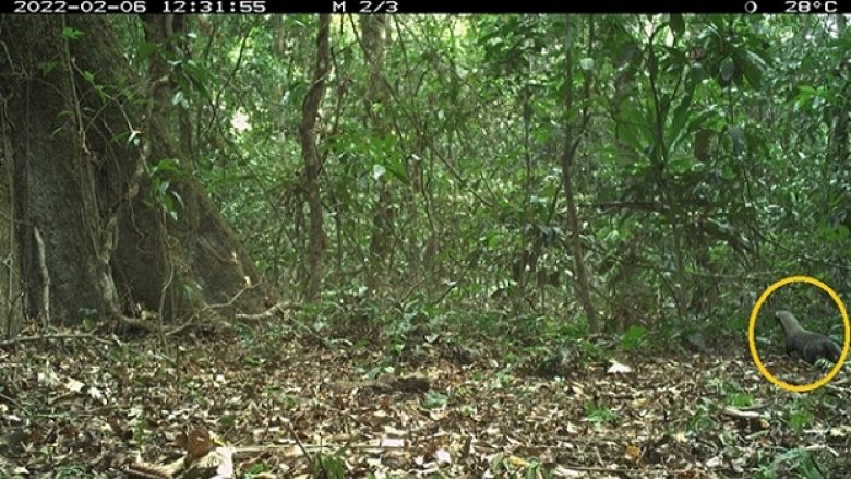
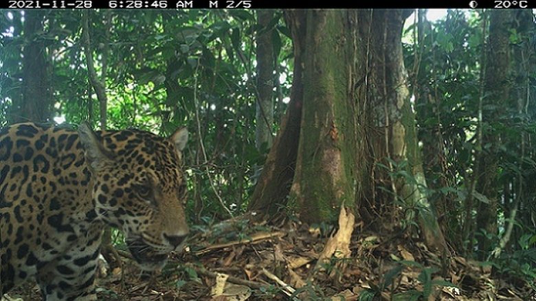
At the pilot site in Colombia’s Guaviare department, results provided data to support continued efforts by the ASL and partner organizations to promote an ecological corridor for jaguars. They confirmed a significant jaguar presence in the area identified to implement the corridor, as well as diverse and abundant prey species. Of the 57 species of mammals and 43 bird and reptile species captured in images, at least 12 jaguar prey species were commonly found. In addition to the jaguar, four other species of felines were detected: Puma (Puma concolor), jaguarundi (Herpailurus yagouaroundi), margay (Leopardus wiedii), and ocelot (Leopardus pardalis). There were also various at-risk species detected, such as the white-lipped peccary (Tayassu pecari) and the giant anteater (Myrmecophaga tridactyla). The images also captured a species that had never been detected in the region before, the greater grison (Galictis vittate). Learn more in this Wildlife Insights story.


Amazon Sustainable Landscapes Program
The greater grison had never been detected in Colombia’s Guaviare department prior to this pilot project.

In Brazil’s Rio Negro Sustainable Development Reserve, the data collected during the pilot provides evidence of the presence and absence of key species in the region. When combined with data from hunting surveys, these findings can help provide insights into the impact of human pressure on biodiversity and will help target the areas that need greater vigilance to combat illegal activity. These findings will be presented by WCS to the management of the Río Negro Reserve for use in evaluating and updating its management plan.

An official from SERNANP (Peru’s National Service of Natural Areas Protected by the State) indicated that the process and information generated from the camera traps will inform the monitoring protocol that is based on key species and aligned with the protected area management plan. They expect to continue using the ASL platform, analyze the data and variables, and be able to measure impacts on species in the long term.

After the pilot activity concluded, new data from ASL’s areas of intervention have joined the platform. Data from the Colombian Guainía region and particularly the Estrella Fluvial de Inirida Ramsar site has been uploaded by SINCHI Institute, an ASL partner. The platform is open to receive more data from other ASL partners in the Amazon, so a future new phase is being explored to incorporate sites in Bolivia, Ecuador, Guyana, and Suriname and provide the capacity building activity. This will come at a time when the WI platform will enable a desktop client version so data can be included even if the user is not online, thus resolving a key challenge in remote areas such as in many important areas for conservation in the Amazon.

This knowledge activity exposed innovative options to evaluate and verify biodiversity outcomes emphasizing the involvement and participation of local communities, as described in the final report. These options will also serve the larger purpose of monitoring the new set of biodiversity-related goals to be ratified in the coming 15th Conference of the Parties (COP15) to the United Nations Convention on Biological Diversity (CBD) in December 2022. Through this and other activities, the ASL continues delivering and promoting best practices and innovative solutions that enable local engagement in conservation measures for the Amazon.


Learn more about the ASL through our website and knowledge management platform.  

Learn more about Wildlife Insights on their website: wildlifeinsights.org

Blogs

    loader image

WHAT'S NEW

    loader image