Executive Summary
Given the fragile and conflict-affected situation with limited access in Myanmar, the World Bank has adopted the Global Rapid Post-Disaster Damage Estimation (GRADE) methodology to estimate damages arising from Cyclone Mocha. GRADE is a remote, desktop analysis to estimate damage to capital stock. This report summarizes the results of the GRADE1 conducted to assess damages following the impact of Extremely severe cyclonic storm2 Mocha in Myanmar during May 2023.
Key Findings
- Total Damages: The median estimate of total direct damage caused by Cyclone Mocha is $2.24 billion, equivalent to 3.4% of Myanmar’s GDP in 2021. This includes damages to residential and non-residential buildings and contents, agriculture, and infrastructure.
- Output Definition: Economic impacts are reported in terms of capital damage, estimated via the GRADE methodology.
- Affected Sectors: Based on damages estimated from reported impacts, the residential housing sector is the hardest hit, followed by non-residential buildings and infrastructure, and then agriculture.
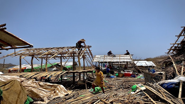
- Spatial Distribution: Over 80% of the damage occurred in Rakhine and Sagaing. Rakhine was the worst affected, with approximately 1.2 million people across seven districts and 17 townships impacted. Internally Displaced Persons camps across Rakhine State, were devastated by the storm, leading to many deaths.
- Points of Interest: (a) The cyclone caused significant damages to five States/Regions in the west and northwestern part of the country: Rakhine, Sagaing, Magway, Mandalay, and Chin; (b) The primary source of damage from Cyclone Mocha in Rakhine State was wind while in Magway and Sagaing regions there was also significant flooding; (c) Infrastructure across the affected regions suffered extensive damage, including health facilities, schools, communication networks, and transportation systems; (d) The ongoing conflict in several regions, particularly in Rakhine State, has exacerbated the impacts of the cyclone and is likely to impact the response and recovery process.
This post-disaster damage estimation effort provides a useful initial estimate of the damages and economic impact caused by Cyclone Mocha in Myanmar and could contribute and complement additional damage and loss assessments involving ground evaluations to plan and design recovery planning and reconstruction.
Residential buildings, non-residential buildings and infrastructure damages are estimated via the GRADE methodology. Published national-level and state/township-level damage reports from local sources have been used for the model (see Annex 2 for detailed references). Data has been cross-checked with georeferenced images and footage from mainstream and social media, and reports from other agencies and organizations.
For residential buildings, non-residential buildings and infrastructure, the analyses at this point evaluate only physical damage to capital stock and do not cover the economic flow losses (e.g. costs of business interruption).
Agricultural damage and losses are estimated based on the disaggregation, quantification, and values of crops from the 2021 Statistical Yearbook and previous agricultural censuses; combined with current yield estimates from state and district agricultural departments. Agricultural losses include damage and production losses.
Estimated Damages
The cost of direct damage to buildings, infrastructure, and agriculture from Cyclone Mocha is estimated at $2.24 billion. This is equivalent to approximately 3.4% of Myanmar’s 2021 GDP. The estimate includes damage due to wind, flooding, storm surge and landslides to residential and non-residential buildings (including building contents), as well as damage to agriculture and infrastructure sector. Table 1 shows the breakdown of the best estimate of direct economic damages in Myanmar by sector and by State or Region, and as a whole for the event. There is some uncertainty around the estimates, due to incomplete damage statistics which were compensated for by using modelling methods. The analyses at this point evaluate only physical damage to capital stock and do not cover the losses as per PDNA3 definition (e.g, business interruption), except for agriculture. The damage to buildings (residential and non-residential) includes building contents. It is estimated that more than 70% of the total damage occurred in Rakhine State. Damage to housing and non-residential buildings and their contents account for over 49% and 18% of the total respectively, while damage to infrastructure and agriculture account for under 22% and 11% of the total respectively.
Table 1 Estimated breakdown of capital damage in absolute values (in US$ millions). The colored bars indicate the relative severity of sectoral damage in each state/region.
To derive the capital damage, the analysis has taken into consideration observational and historical information in the region. Published damage reports from May 12 to June 8 were used from, among others, the National Disaster Management Committee and Ministry of Humanitarian Affairs and Disaster Management, as well as other state and township level data from news reports and public agency reporting. This has been cross-checked with georeferenced images and footage from mainstream and social media, and flood footprints derived from satellite imagery and flow gauge data from Myanmar’s Department of Meteorology and Hydrology.
The greatest damage occurred in Rakhine State and Sagaing Region, which together account for nearly 84% of the total accumulated damages. Rakhine, as the state that was hit hardest, experienced total damage that amounted to almost 30% of its total capital stock.
